The Ancient Saar Project: London-Bahrain Archaeological Expedition
Robert C Killick, 2007 (updated 2017)
The excavations at Saar, Bahrain, took place between 1990 and 1999. The work was undertaken by the London-Bahrain Archaeological Expedition which was formed specifically for the purpose. The UK academic supporter of the project was the Institute of Archaeology, University College, London. In Bahrain, the Expedition received the patronage of the Amir, the late Shaikh Isa bin Sulman Al-Khalifa. The project was funded mainly by the business community in Bahrain, as well as by the British Academy and other academic funding bodies (for a full list, see Appendix 1 in Saar Volume 3). The directors were Robert Killick, Jane Moon, and Harriet Crawford (for the period 1990-5).
The site of Saar had been previously excavated by a Jordanian expedition (results unpublished) and it was clear from that work that the settlement was inhabited for part of the Early Dilmun period (late third and early second millennia BC) and then abandoned. This corresponds to the period of Bahrain's involvement in Arabian Gulf trade when commodities were shipped through Bahrain, from Oman and the Indus, on their way to the cities of southern Babylonia, and vice versa. A procedure documented, if patchily, in the cuneiform records of the time.
Nearly all previous archaeological work on this period prior to the excavation of Saar has focused on the extensive burial mounds and on isolated temples. The importance of Saar, therefore, resides in the fact that it is the first (and currently only) Early Dilmun settlement to have been investigated in any detail. This importance has been recognised by the Government of Bahrain which has placed the 'Saar Heritage Park' on the Tentative World Heritage List.
The Saar Settlement
The settlement itself is located on a small but prominent eastern outcrop of a limestone ridge which provides about the only natural elevation in the northern part of Bahrain. Immediately west of the settlement, and on the highest part of the ridge, is the Saar burial field, while to the south there are two cemetery complexes of interconnected graves. The settlement is spread over an estimated area of between 15,000 and 23,000 sq m, of which 7,500 sq m was excavated by the end of the project. Saar is a well laid out settlement with a main street running up from the southeastern outskirts; a temple in the centre at the crossroads of the settlement; and two- and three-roomed buildings, constructed in rows (e.g. Block A) with standard room plans and suites of domestic installations. Over 80 buildings, mainly houses, were investigated by the Expedition, as well as a well and a gypsum kiln. All these are described in detail in Saar Report 3. On the basis of pottery comparisons, the duration of the settlement is currently estimated to be about 250 years, from 2100 to 1850 BC approximately.
Reports:
Saar Excavation Report 1
The Dilmun Temple at Saar
edited by Harriet Crawford, Robert Killick, and Jane MoonFull Report 11 Mb Saar Excavation Report 2
Early Dilmun Seals from Saar, fragments of art and administration
by Harriet CrawfordFull Report 6 Mb Saar Excavation Report 3
The Early Dilmun Settlement at Saar
by Robert Killick and Jane MoonFull Report 45 Mb Database Documentation:
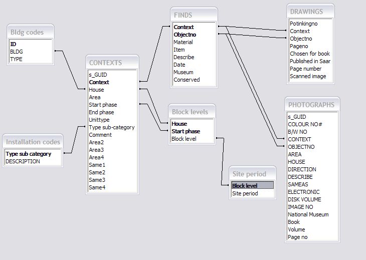
Database Documentation 54 Kb Entity Relationship Diagram JPG 48 Kb Database Tables:
ARCHITECTS PLANS CSV 12 Kb Bldg codes CSV 1 Kb Bldg measurements CSV 4 Kb Block levels CSV 6 Kb CONTEXTS CSV 730 Kb DRAWINGS CSV 27 Kb FILE LIST CSV 5 Kb GRAVES CSV 4 Kb FINDS CSV 2.08 Mb Installation codes CSV 1 Kb Pottery periods CSV 2 Kb PHOTOGRAPHS CSV 520 Kb Pot versus strat CSV 5 Kb Room types CSV 1 Kb SAMPLING CSV 53 Kb SECTIONS CSV 20 Kb Site period CSV 1 Kb SITE SUPERVISORS PLANS CSV 45 Kb JPG Images:

Bahrain map
Early Dilmun sites in BahrainJPG 53 Kb 
Cemeteries
The Northern Burial ComplexJPG 266 Kb 
Double chamber burials
Two-tier Early Dilmun burials along the southwestern edge of the Saar mound-fieldJPG 267 Kb 
Honeycomb cemetery
Part of the Southern Burial ComplexJPG 313 Kb 
Middle East map
Southwestern AsiaJPG 153 Kb 
Saar area map
Archaeological remains in the Saar areaJPG 155 Kb 
Settlement limits
Location and extent of the Saar settlementJPG 118 Kb 
Site aerial
The Early Dilmun settlement at Saar from the air, taken in 1993 (S)JPG 272 Kb 
Site and eastwards
The plain to the east of the settlement (E)JPG 350 Kb


 Stumble It!


No comments:
Post a Comment