Sunday, September 30, 2018

The Digital Archaeological Atlas of the Holy Land

[First posted in AWOL 11 August 2011, updated 30 September 2018]

The Digital Archaeological Atlas of the Holy Land


Coming Soon: Virtual Reality on the Web! VR Walk-throughs of Archaeological Sites in the Lower Kidron Valley!
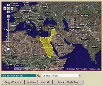
The Digital Archaeological Atlas of the Holy Land (DAAHL) is an international project that brings together experts in information technology including Geographic Information Systems (GIS) and the archaeology of the Holy Land (modern Israel, Palestine, Jordan, southern Lebanon, Syria and the Sinai Peninsula) to create the first on-line digital atlas of the region held sacred to the three great monotheistic faiths - Judaism, Christianity and Islam. Using the power of spatial information systems such as Google Maps and Google Earth, GIS, the tens of thousands of recorded archaeological sites for the region - from the remote prehistoric periods to the early 20th century - will be entered into a comprehensive database along with site maps, photographs and artifacts. The historical and archaeological content for this project will be developed by a team of over 30 international scholars working in the region, helping to provide the data used to create the Atlas. This website and its content will serve as the prototype "knowledge node" of a more comprehensive Digital Archaeological Atlas Network for the Mediterranean region.


The site now contains a variety of Google Maps interfaces that let you explore the region and the archaeological resources it contains. The link bar under the DAAHL header provides access to the main functions currently available in the website. These include:

The Mediterranean Archaeological Network or MedArchNet is one of the first attempts to create 'Portal Science' for archaeologists and the interested public. Consequently, a major goal of MedArchNet is to make archaeological data from the Mediterranean lands accessible to various communities, including school teachers, tourists and travel agents, university students and professors, researchers, and public policy makers. MedArchNet taps into the fast-growing field of 'portal science' and will serve researchers and explorers as a platform for international collaboration, while also allowing the general public to share in the excitement of archaeology and discovery. This link takes you to the MedArchNet homepage.
Empires presents one set of examples of Global Moments in the Levant. On this page the DAAHL includes an interactive Google Maps interface that presents the rise and fall of empires in the ancient world. The map can be animated to display the empires across time; individual empires can be selected to display summary information, and archaeological sites extant during the empire's time span can be displayed and queried on the map.
Archaeological Periods organize over 17,000 sites in the DAAHL database by more than 60 time periods from the Lower Paleolithic, more than 2 million years ago, to the Late Ottoman period, which ended in 1918. A Google Maps interface lets the user animate site clusters through time, and explore the distribution of archaeological sites in the Levant during any of these periods. Short introductions to the time periods are included as well.
Shishak's Campaign presents information related to the Egyptian Pharoah Sheshonq I (known in the Hebrew Bible as Shishak) and his military expedition into southwestern Asia. His invasion of Judah and Israel is documented on the south wall of the Temple of Amun Ra at Karnak, and described in the Bible (1 Kings 11:40; 14:25; 2 Chronicles 12:2-9). The DAAHL uses the latest "tour" capability in the Google Earth API to track some of the movements of Shishak's army.
Case Studies are specialized, in depth explorations of different subjects in the atlas. Tom Levy's exploration of the Edomite Lowlands during the Iron Age, which is accompanied by an interactive Google Maps display, is a prime example. Other case studies are presented as online Powerpoint or HTML presentations.
About the Atlas displays information about the main research partners who are developing the atlas. The Atlas is an international project that brings together experts in information technology and Levantine archaeology to create the first on-line digital atlas of the region held sacred to the three great monotheistic faiths - Judaism, Christianity and Islam.
PEF Maps are maps produced for the Palestine Exploration Fund by Claude R. Conder of the British Ordanace Survey in the 1870s and 1880s. These classic maps contain more than 10,000 place names, and are an important resource for Late Ottoman period Palestine. The GAIA Lab at Arizona State University converted the map sheets into more than 50,000 tiles in an interactive Google Maps display that can be zoomed and panned to show the maps in the background, with the DAAHL archaeological sites superimposed.
Search Database opens a page in the website where users can query the database by such things as site name, time period, site type, site conditions, etc. Queries are submitted to the DAAHL web server and the results are returned to the user as dynamic kml, which opens on the user's computer in Google Earth. All sites displayed in the result sets are "backlinked" to the DAAHL database, so they can be explored indiviually by following their links. See the video below for an example of a time period search.
The Spatial Search link opens a page with in interactive Google Maps display. The user can draw an irregular region of interest on the map and perform a search for all the sites in the DAAHL database that fall within one kilometer of the search region. Like the database search, results are displayed as points in Google Earth; the user can determine the point display style, and all search results are back-linked to the Atlas.
Use the Make Maps function to make queries of sites by time period and/or site/feature type, and display the results on a Google Maps interactive map that includes site clusters and individual sites. Clusters can be clicked to zoom to the next level, displaying smaller clusters and individual sites.  Hover over site points to see the site name.  Use your computer's screen copy function to copy the map; then paste it into a graphics editing program and crop it to the map--then you can use the map in presentations or documents.
Site Preservation links to a page in the DAAHL website that displays two film clips. The first shows how the Spatial Search is done, and illustrates how this function can be used to help preserve archaeological sites by minimizing the impact of development projects through avoiding sites. The second film clip is a trailer to a movie that discusses the danger to one of Jordan's most significant Early Bronze Age sites posed by expanding gravel quarries.
Contributors to the DAAHL project have come from many countries, universities, and research institutions. All sites and project data that are contributed to the DAAHL are "branded" with the contributor's information and cross-linked to their websites. The DAAHL database safeguards our contributor's information and drives website traffic to their research projects.

1 comment:

  1. very interesting, not least because we did something very similar a few years ago: http://map.belteshazzar.com

    ReplyDelete